
Top 10 Waterfalls in Iceland.
Iceland is well-known for its abundance of waterfalls. These spectacular landmarks are spread all over the country. But which one should you definitely visit if you’re planning on visiting the country?
Here are the top 10 must-see waterfalls in Iceland:

Godafoss waterfall
Location: North Iceland (34,5KM from Akureyri)
How to get there: Directions on Google maps
Godafoss, often nicknamed ‘the waterfall of the gods’ due to its godlike beauty and religious connotation is the most famous waterfall of the Skjálfandafljót region and one of the most famous waterfalls in the country.
This waterfall is 12 meters high and 30 meters wide. It is normally featured on the Diamond Circle route. According to national folklore, chief Þorgeir Ljósvetningagoði propelled a religious breakthrough in the country upon throwing the figures of the Old Norse Gods into the waterfall, in order to convey the nation’s conversation to Christianity.

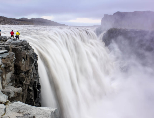
Dettifoss waterfall
Location: North-East Iceland (89KM from Husavik)
How to get there: Directions on Google maps
Dettifoss is the waterfall with the greatest volume in Europe, with 500 cubic metres of water passing by, per second. It is also known to be the most powerful waterfall in the continent. Situated in the north of Iceland, Detifoss is fed by Jökulsá á Fjöllum, a dominant and all-powerful river glacier. Jökulsá á Fjöllum stems from Vatnajökull, the largest glacier in the country and Europe, in its entirety. This waterfall can be found in the Vatnajökull National Park, Iceland’s biggest natural park. This waterfall is also located north of the Ring road, the Icelandic main road. There are two routes that connect the road to Dettifoss.
Please note: Driving in the winter can be difficult, due to the adverse weather conditions.

Gljúfrabúi/Gljufrafoss waterfall
Location: South Iceland (129KM from Reykjavik)
How to get there: Directions on Google maps
Gljúfrafoss or Gljúfrabúi, meaning ‘one who lives in the canyon’ or ‘canyon dweller’ is a rather small waterfall located in Hamragarðar, in the south of Iceland. This waterfall is hidden behind a sizable cliff, thus giving the location a ‘hidden gem’ reputation. Gljúfrafoss is normally overlooked by tourists due to its location, therefore, it is a great place for photographers who wish to take some amazing shots of nature in its most natural form or even those who wish to find some peace and quiet amongst nature. If you’re planning on hiking, you’ll be able to follow a trail to enter the narrow canyon —it will then plummet onto a small pool. A wooden staircase is also in place for those who wish to climb halfway and take in the magnificent views.

Gullfoss waterfall
Location: South Iceland (117KM from Reykjavik)
How to get there: Directions on Google maps
Gullfoss, meaning ‘Golden Falls, is arguably the most iconic and beloved waterfall in Iceland. It can be found in south-west Iceland, in the Hvítá canyon. This waterfall is located within the Golden Circle route, thus being a popular landmark for those visiting Iceland for the first time. This waterfall has a curious particularity: it is displayed in two distinct stages. Firstly, the water journeys through the glacier Langjökul and then it cascades down Gullfoss, 32 meters down.
During the summer, more than 140 cubic metres surge down the waterfall. During the winter, this number drops to 109 cubic metres.
It is thus a rather powerful waterfall and visitors might have to face the possibility of getting drenched due to its astounding force. Bring a spare set of clothes with you!

Háifoss waterfall
Location: The highlands in Iceland (142KM from Reykjavík)
How to get there: Directions on Google maps
Háifoss, meaning the ‘High Waterfall’, is a waterfall in Fossárdalur valley, in south Iceland. It is 122 metres tall, thus being the third tallest waterfall in the country. It is fed by the river Fossá, which then drains into Þjorsá, the largest river in the country. Near Háifoss, a second, smaller waterfall can be found. This landmark is called Granni, meaning ‘neighbour’.
Both features can be watched together from the viewing point, on the south side of the falls. If you’re keen on photography, you’ll also be able to capture both in the same frame.
National folklore claims that the area is the home of an ogress, who used to fish trout from the falls, threatening anyone who dared to come nearby.

Seljalandsfoss waterfall
Location: South Iceland (128KM from Reykjavík)
How to get there: Directions on Google maps
Seljalandsfoss is a waterfall situated on the South Coast of Iceland. It can be fully encircled and has a drop of 60 metres. It is one the most visited and photographed waterfalls in the country, due to its proximity to the famous Ring Road route and its majestic features. Seljalandsfoss is part of the river Seljalandsá, which originates from the glacier Eyjafjallajökull.
The cascade of the fall is rather narrowed, however, it falls from a tall cliff, which was once a marker for the country’s coastline.
The most particular feature of Seljalandsfoss is the pathway encircling the waterfall in its entirety. Additionally, the cliff behind the falls hides a wide cavern and several paths which allow guests to explore it during the summer.
Please note: Visitors should be prepared for the great dampness of this location, due to the mist of the falls. Paths and rocks also tend to be slippery.

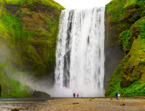
Skógafoss waterfall
Location: South Iceland (156KM from Reykjavík)
How to get there: Directions on Google maps
Skógafoss is one of Iceland’s biggest waterfalls with a width of 25 meters and an astounding drop of 60 meters. Located on the south coast of Iceland, this waterfall is the perfect place for a pit-stop if you’re feeling tired from all the travelling. The fall is also visible from Route 1. The river underneath Skógafoss is well-known to have salmon and char galore, thus being a beloved spot for fishermen during the summer. Due to its spray production, it is possible to witness a rainbow near the waterfall, any time the sun peaks from behind the clouds.
The land behind Skógafoss is rather flat, being an excellent location for visitors to walk towards the wall of water. Alongside, a steep staircase leading to an observational viewing point is also in place for those who wish to observe the view from above.

Svartifoss waterfall
Location: South East Iceland (141KM from Vik in Myrdal)
How to get there: Directions on Google maps
Svartifoss or ‘Black falls’ is a unique waterfall in south Iceland. Located in the Skaftafell National Park, it is a beloved attraction for those who visit the area. The waterfall is fed by the meltwater from the Svinafellsjokull glacier. Svartifoss drops down 20 metres over a cliff, bordered by black basalt columns on both sides — thus giving the waterfall its name.
The architecture of Svartifoss inspired locations such as Iceland’s National Theatre and the Hallgrimskirkja church in Reykjavik.
It is possible to hike to Svartifoss, the route begins at the visitor centre in Skaftafell and lasts for about 45 minutes (one way). Throughout the path to the waterfall, you’ll stumble upon three other waterfalls: Þjofafoss, Hundafoss and Hundafoss. Upon arrival, you’ll encounter a small bridge close to the waterfall which will allow getting closer to the wall of water.

Glymur waterfall
Location: West Iceland (71KM from Reykjavik)
How to get there: Directions on Google maps
Glymur is the second tallest waterfall in the country, and the tallest that is accessible by walking. Situated the fjord of Hvalfjörður, it is 198 metres tall. The waterfall is fed by the river Botnsá.
It is possible to hike to the waterfall from Glymur’s carpark. The journey towards Glymur’s carpark takes approximately 45 minutes by car, if driving from Reykjavík. Upon arrival, the hike takes approximately three and a half hours.
Please note: The hike towards Glymur is challenging. There are no paved roads and the most commonly used route involves wading across a river with the aid of a rope, diving into a cave and walking along a narrow mountain path.

Hraunfossar waterfalls
Location: West Iceland (71KM from Reykjavik)
How to get there: Directions on Google maps
The Hraunfossar waterfalls, commonly known as ‘lava falls’ are a magnificent treasure of nature. They comprise a plethora of creeks and cascades which stream out lava over a distance of 900 metres. These waterfalls were formed out of Hallmundarhraun, a lava field, born out of the eruption of one of the existing volcanoes underneath the Langjokull glacier. These waterfalls are recognised for their turquoise blue waters. The water surges through the ground — then draining into the Hvita River. There is a rather good viewing at the car park which offers magnificent views over the waterfalls. There is also a hiking trail connecting Hraunfossar to a nearby waterfall — Barnafoss.


